
The story of the Pacific salmon is one of nature's most incredible journeys. Each year, these powerful fish leave the vastness of the ocean to navigate back to the exact freshwater stream of their birth, a heroic upstream migration driven by an ancient, genetic blueprint. This journey is not just a biological wonder; it's a cornerstone of ecosystems and a pillar of cultural and economic life for communities stretching from the Pacific Northwest to Alaska and beyond. Yet, for decades, this epic saga has been tragically interrupted. Human-made obstacles—massive dams, poorly designed culverts, and sprawling urban development—have turned once-open highways into dead ends, causing salmon populations to plummet.
The challenge facing conservationists and fisheries managers has been immense: how do you get a clear picture of what's happening to millions of tiny fish in thousands of miles of river systems? You can't simply follow them with a boat or a drone. The answer, it turns out, is a marvel of miniature technology: the Passive Integrated Transponder, or PIT tag. These tiny trackers are providing the data and insights needed to pinpoint problems and guide effective, large-scale restoration efforts, giving salmon a fighting chance to complete their life-affirming journey.
The Perilous Journey: Why Salmon Need Our Help
Salmon are anadromous fish, meaning they live in saltwater but return to freshwater to spawn. This migration is a biological imperative, a finely tuned process that has evolved over millennia. A single salmon run can transport millions of marine-derived nutrients from the ocean deep into terrestrial ecosystems. Bears, eagles, and other wildlife depend on this seasonal bounty. The economic impact is equally significant, supporting commercial and recreational fisheries that are worth billions.
But the obstacles are formidable. Dams, in particular, create vast, still reservoirs that disorient young fish (smolts) trying to get to the ocean. The journey back as adults is even more challenging, with fish ladders sometimes proving to be inefficient or even impassable. In the Columbia River Basin alone, a series of 18 dams forms the largest hydroelectric system in North America, profoundly altering the river's hydrology and posing a gauntlet for migrating fish. Climate change further compounds these issues, with rising river temperatures making upstream travel a literal life-or-death struggle. The traditional methods of observation—visual counts at fish ladders or trap-and-haul operations—provided only a limited, often incomplete, snapshot of success. This is where the innovation of Pit tags changed the game.
What Is a PIT Tag and How Does It Work?
A PIT tag is not a GPS tracker. It’s a passive device, a tiny glass-encapsulated microchip with a unique, 10-digit identification code. Roughly the size of a grain of rice, it has no internal battery. When a fish carrying a tag swims past a reader antenna, the antenna emits a low-frequency radio signal (typically 134.2 kHz) that powers the tag. The tag is energized just long enough to transmit its unique code back to the antenna, which then records the code, along with the time and date, in a data logger. This instantaneous "ping" creates an individual data point for that specific fish at that specific location.
This "passive" nature is its greatest strength. Because they don't rely on a battery, these tags can last for the entire lifespan of the fish—sometimes over a decade. This makes them ideal for tracking long-term survival and migration success. They are also non-invasive, surgically implanted into the fish's body cavity using a hypodermic needle. The procedure is quick, with minimal stress to the fish, and studies have shown no significant effect on their growth, survival, or behavior. This makes them a humane and scientifically sound choice for conservation research, especially when compared to older, more cumbersome methods.
From Ping to Policy: The Data Revolution
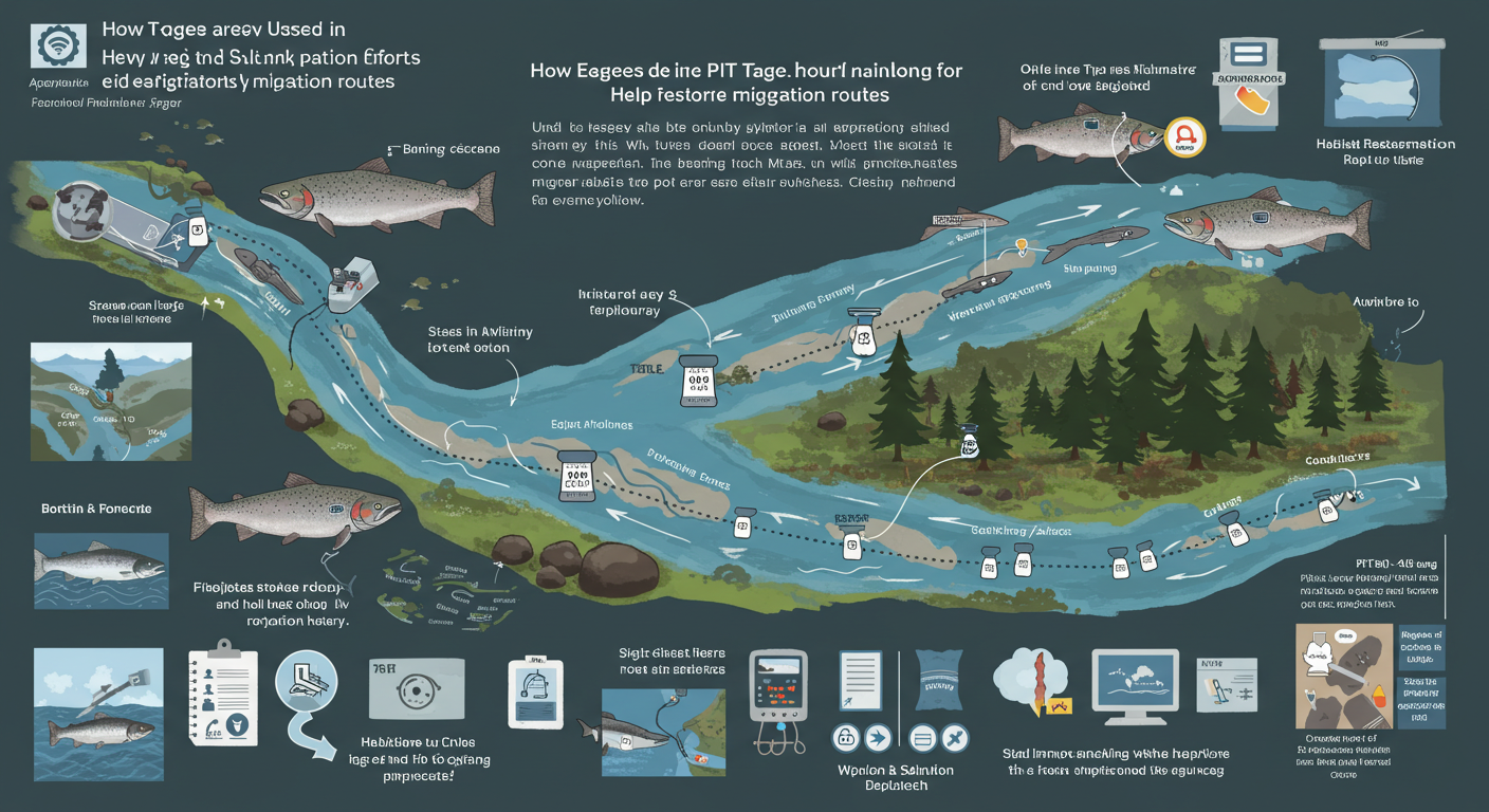
The real power of pit tags comes not from a single detection, but from a network of thousands of strategically placed readers. In a large river basin like the Columbia-Snake system, antennas are installed at key points, including:
- Dams: Antennas are embedded in the concrete of fish ladders and juvenile bypass systems, recording every single fish that passes. This provides critical data on the efficiency of these structures.
- Tributaries: Readers at the mouths of smaller streams and creeks can confirm whether fish are successfully reaching their natal spawning grounds.
- Juvenile bypass systems: These systems are designed to safely guide juvenile fish around dam turbines. PIT tags help scientists determine how many fish are using the bypasses versus other, more dangerous routes.
- Culverts and road crossings: Smaller-scale antennas can be installed in streams to evaluate whether a culvert is acting as a barrier to fish passage.
By analyzing the data from this interconnected grid, scientists can create a detailed, real-time map of a salmon's journey. They can calculate travel times between dams, pinpoint where fish are getting stuck, and determine survival rates through different sections of the river. If a fish tagged at an upstream hatchery is never detected at a downstream dam, it tells a story of mortality. If a large number of fish are seen attempting to enter a fishway but are not detected exiting, it signals a significant bottleneck. This empirical evidence is invaluable. It transforms guesswork into a data-driven approach, allowing managers to prioritize restoration efforts where they will have the greatest impact. For example, if data from these tags show that a particular fish ladder is only 50% efficient, it provides a strong scientific basis for upgrading or redesigning that structure.
Real-World Success Stories
The impact of pit tags is most evident in the Columbia River Basin, where they have been a central tool for over three decades. The Pacific States Marine Fisheries Commission's PIT Tag Information System (PTAGIS) is a massive database that stores and manages detection data from millions of tagged fish. This network has been instrumental in a range of conservation successes:
- Optimizing Dam Operations: Data from PTAGIS has informed real-time operational decisions at dams. For instance, operators can adjust spillway flows to coincide with the movement of juvenile salmon pulses detected by upstream antennas, improving safe passage.
- Culvert Replacement: In countless smaller tributaries, PIT tag studies have confirmed that poorly designed culverts are complete barriers to upstream migration. This concrete data has led to successful projects to replace those structures with fish-friendly alternatives, re-opening hundreds of miles of spawning habitat.
- Assessing Hatchery Programs: By tagging hatchery-reared fish, managers can compare their survival and migration success to that of wild fish. This helps to refine hatchery practices, ensuring that they are producing fish that are well-equipped for their migratory journey. Data from pit tags has been used to determine optimal release locations and even to assess the survival of returning adults, providing a full-circle understanding of the life cycle.
Beyond the Pacific Northwest, these tags are being used globally. Projects in Europe, for instance, are using tags to monitor the restoration of rivers and streams, helping to bring back native fish species whose migration routes were fragmented by centuries of industrial development.
The Future of PIT Tagging: Beyond the Rivers
While the traditional application of pit tags in river systems has been a resounding success, the technology and its applications continue to evolve. Researchers are now deploying mobile and even autonomous detection systems, such as antenna trawls and robotic barges, to track fish in vast, open water environments like the Columbia River estuary. This provides a more comprehensive understanding of survival as fish transition from freshwater to saltwater. The future will likely see the integration of pit tags with artificial intelligence and machine learning, allowing for predictive modeling of fish movement based on environmental factors like water flow and temperature.
The science is clear: these small, passive trackers provide the critical, individual-level data that is essential for understanding the complexities of large-scale fish migration. They provide a clear and undeniable narrative of what's working and what isn't, guiding conservation with a precision that was unimaginable just a few decades ago. By helping us to see and understand the challenges salmon face, pit tags have become a beacon of hope in the ongoing, urgent effort to restore their rightful place in our rivers and oceans.
Conclusion: A Small Tag's Monumental Impact
The story of salmon restoration is a powerful example of how a simple, elegant piece of technology can provide the foundation for monumental change. The journey of a single, tagged fish becomes a data point, and thousands of these data points build a comprehensive, scientific road map for conservation. The use of pit tags has moved restoration from a hopeful endeavor to a strategic, evidence-based science. It’s a testament to the idea that by listening carefully—in this case, to the silent pings from a tiny, tireless tracker—we can give one of nature’s most remarkable creatures the best possible chance to find its way home.